
In an urban culture, millions of people and most areas remain rural
On our walls we have a couple of maps of the US that show the degree to which counties are rural or urban. For states in the eastern half of the country with relatively small counties, this works reasonably well, but even there problems arise. A more significant problem arises in the West where the counties are very large when compared to those in the East.
Most often a county like San Bernardino, California is marked as an urban county because of a large population base in the southeastern part of the county around the city of San Bernardino. At the same time over 75% of the land consists of mountains and largely uninhabited areas of the Mohave Desert.
Recently the USDA, Economic Research Service added a rural definitions data set to its website: http://www.ers.usda.gov/Data/RuralDefinitions/. On this website the USDA provides a variety of tools that can be used to look at nine different definitions that identify areas that are rural as compared to urban.
In this brief column we do not have space to look at all of them so we will focus on just a couple, using the state of Illinois as an example. One set of definitions uses the population of census places—basically incorporated and unincorporated places that serve as community centers. Using the numbers, the USDA offers three different cutoffs between rural and urban: all areas outside census places with 2,500 or more people; 10,000 or more people; and 50,000 or more people.
Figure 1 shows the results of applying these definitions to Illinois. As is to be expected, Greater Chicago, Rockford, Peoria, Bloomington, Springfield, Champaign, and Decatur show up as urban and the rest of the state is rural with a number of county seats and other rural business centers scattered throughout the state. This map shows large areas that are open to the growing of corn, soybeans and other agricultural products.
Contrast that map with Figure 2 which uses the Office of Management and Budget definition of metro with the remaining counties being considered non-metro or rural. Large swaths of the state are marked metro, even if a lot of corn and beans are grown in some of those counties.
So what percentage of Illinois’ population and area is rural? It all depends upon the definition you use. In Illinois 19 percent of the population lives outside census places with a population greater than 2,500 with 94 percent of the land being considered rural. At the same time 29 percent of the population lives outside of census places with a population greater than 10,000 with 96 percent of the land being considered rural.
If you raise the threshold to 50,000 then 60 percent of Illinois residents are rural—living outside the seven cities listed above—as is 99 percent of the land. Using the Office of Management and Budget definition of metro areas results in 14 percent of Illinois’ people being considered rural as is 49 percent of the land.
The USDA site has maps and similar statistics for all states.
Not only are these numbers fascinating, they are politically important. If one wants to minimize the importance of farming and rural areas then the set of numbers to use are those that result from OMB’s metro-non-metro distinction which minimizes the size of non-metro population groups. On the other hand if one wants to show the continued relevance of rural issues then using a threshold of 50,000 includes 63 percent of the US population and 99 percent of the land.
This site is one that will be invaluable for rural policy analysts. We commend the USDA for making this information available.
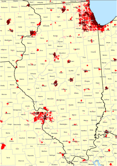
Figure 1. Three definitions of rural based on census places. The darkest places are those with a population>= 50,000. The other three levels are <2,500, < 10,000, and < 50,000. Source USDA
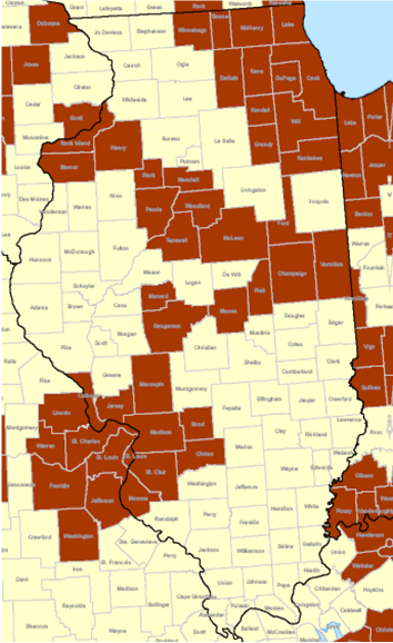
Figure 2. Rural definition based on Office of Management and Budget metro counties for Illinois. The darkest places are metro counties and the light counties are rural—non-metro. Source USDA
Daryll E. Ray holds the Blasingame Chair of Excellence in Agricultural Policy, Institute of Agriculture, University of Tennessee, and is the Director of UT’s Agricultural Policy Analysis Center (APAC). (865) 974-7407; Fax: (865) 974-7298; dray@utk.edu; http://www.agpolicy.org. Daryll Ray’s column is written with the research and assistance of Harwood D. Schaffer, Research Associate with APAC.
Reproduction Permission Granted with:
1) Full attribution to Daryll E. Ray and the Agricultural Policy Analysis Center, University of Tennessee, Knoxville, TN;
2) An email sent to hdschaffer@utk.edu indicating how often you intend on running Dr. Ray’s column and your total circulation. Also, please send one copy of the first issue with Dr. Ray’s column in it to Harwood Schaffer, Agricultural Policy Analysis Center, 309 Morgan Hall, Knoxville, TN 37996-4519.